|
As Canadian cities grow, the demand for smarter, real-time public transportation solutions becomes more urgent. From Toronto to Vancouver, Montreal, Calgary, Ottawa, and Edmonton, transit agencies and property managers are looking for ways to keep commuters informed, reduce wait times, and improve the passenger experience. Navigo TransitAccess, the real-time digital transit signage solution by ITS / iTouchInc, is positioned to meet that need.
|
What is Navigo TransitAccess?
Navigo TransitAccess is a digital signage platform designed specifically for the transit & transportation sector. It enables transit authorities, property developers, airports, metro hubs, and offices to show live transit data, maps, arrival/departure times, traffic conditions, and more—on both touchless and touchscreen displays. It integrates with GTFS / GTFS-Realtime feeds (the standard in many Canadian transit systems), plus maps, weather, third-party mobility options (bike-share, car-share), and branded widgets. itouchinc.com
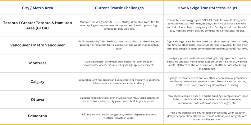
Key Benefits for Canadian Metropolitan Areas
Below are how various large Canadian metro regions can benefit from (or already might benefit by adopting) Navigo TransitAccess:
Features That Matter in Canada
-
GTFS / GTFS-Realtime Integration: Most Canadian transit systems already publish GTFS data (or are moving toward it). Navigo supports pulling GTFS-RT feeds to show up-to-the-moment arrival and departure times. itouchinc.com
-
Multiple Mobility Options: Bike shares, car shares, scooter shares are growing in many Canadian cities. Displays showing availability helps commuters plan “first-/last-mile” travel.
-
Weather & Alerts: With the variable climate—from snowstorms in Montreal to heavy rain in Vancouver to sudden snow in Calgary—weather forecasts and alerts are essential. TransitAccess includes weather and severe‐weather alert feeds. itouchinc.com
-
Traffic Maps & Drive Times: For commuters who mix driving and transit, or for people checking traffic before deciding on transit vs car, live traffic maps with drive times add real value.
-
Custom Flyers / Brandable Widgets: Local transit authorities want signage that matches branding, supports bilingual requirements, possibly Indigenous language needs, especially in places like Ottawa or Montreal. Navigo allows for branded/custom widgets.
-
Offline / Fail-Safe Functionality: In case of network outages or during extreme weather, displays must keep functioning. Navigo includes edge caching/offline continuity with automatic resync when back online.
Why Now Is the Time for Canadian Cities to Adopt It
-
Growing demand for transparency and real-time information: Commuters expect to know delays, arrivals, and alternative options immediately.
-
Shared mobility is rising: Bike-share, car-share, scooter programs are expanding in many metros. Bridging all options into a single transit signage ecosystem simplifies navigation.
-
Smart city / sustainability goals: Many large Canadian cities have sustainability plans (less car use, more public transit). Enabling better transit signage helps encourage public transport usage.
-
Technological infrastructure is catching up: With widespread cellular / broadband connectivity, municipalities / agencies have the backend to support real-time data feeds.
Where TransitAccess Signs Should Go in Canadian Metro Areas
-
Major transit hubs (metro, commuter rail, bus terminals)
-
Airport transit connections
-
Business districts and office lobbies
-
Universities, hospitals, large residential complexes
-
Shopping malls and large mixed-use developments
-
Outdoor shelters with protected screens
Potential Implementation Steps
Assess existing signage & hardware: Some locations may already have LED or LCD screens that can be upgraded just via software subscription. TransitAccess® allows customers to use existing screens.
-
Identify transit agency GTFS / GTFS-RT data: Determine which feeds are available locally, e.g. via municipal transit authority or province.
-
Customize display content: Decide what to show: next arrivals, weather, mobility options, traffic, maps, etc. Pick branding, languages.
-
Choose display locations & screen sizes: High-traffic, visible areas; ideal sizes 43" & above for shared view. itouchinc.com
-
Install and test: Setup subscription, connect data feeds, test for responsiveness, reliability.
-
Manage ongoing content & updates: Leadership needs to monitor service alerts, maintenance schedules, and ensure real-time information is accurate.
The Key Takeaway
Imagine installing Navigo TransitAccess screens at Union Station, Pillars of the PATH network, in Mississauga city hall, or in York University. These screens could aggregate TTC, GO Transit, MiWay, Brampton Transit schedules, show live SkyTrain equivalents (if applicable), bike share or e-scooter status, and display weather, transit alerts, etc. The result: commuters feel more empowered, fewer delays, less frustration.
Large Canadian metropolitan areas (Toronto, Vancouver, Montreal, Calgary, Ottawa, Edmonton) can benefit greatly from adopting robust real-time transit signage solutions—providing accuracy, transparency, and better commuter experience. Navigo TransitAccess offers an integrated, scalable, customizable platform designed for exactly such contexts. As Canada’s urban centres grow and transit systems become more complex, real-time digital signage is not just a “nice-to-have”—it’s a strategic necessity.
Explore itouchinc.com for more information on our solutions or contact us for needs unique to your property or project.
|